
Bến Tre
Bến Tre
Thành phố Bến Tre | |
|---|---|
| Bến Tre City | |
 Skyline of Bến Tre | |
 Seal | |
 | |
 Bến Tre Location of Bến Tre | |
| Coordinates: 10°14′N 106°23′E / 10.233°N 106.383°E | |
| Country | |
| Province | Bến Tre |
| Area | |
| • Total | 65.75 km2 (25.39 sq mi) |
| Population (2019) | |
| • Total | 124,449 |
| • Density | 1,893.52/km2 (4,904.2/sq mi) |
| Time zone | UTC+7 (ICT) |
| Climate | Aw |
| Website | https://bentre.gov.vn/ |
Bến Tre (Vietnamese pronunciation: [ˀɓən˦ˀ˥ ʈɛ˧˧] ) is the provincial capital of Bến Tre Province, in the Mekong Delta region of southern Vietnam. Located 85 kilometers (53 mi) southwest of Ho Chi Minh City, the city covers an area of 65.75 km2 (25.39 sq mi) and has a population of 124,499 at the 2019 census.[1] Bến Tre is connected to the surrounding provinces by the Rạch Miễu Bridge and is also where the import National Highway 60 passes through.
Etymology
[edit]The name "Bến Tre" was formed by associating the natural terrain with the name of a tree specie (meaning wharf with many bamboos growing), this name appeared from the Nguyễn Dynasty,
History
[edit]Early history
[edit]At the end of the 17th century, the current city of Bến Tre was still sparsely populated. By the following century, many groups of people from the Central Vietnam and neighboring provinces began to migrate to this area to settle. In the early days of settling, the inhabitants concentrated on high mounds, along rivers and canals to easily establish villages.
French rule
[edit]As an administrative center, it was not until the French colonialists occupied the province and established the first Tham Biện (Inspection) office on the banks of the Bến Tre canal in June 1867. On January 1, 1900, Governor-General Paul Doumer applied the decree to change the Tham Biện office to a province, Bến Tre was officially called a province from then on, and established the provincial capital at its current location.
1945 to 1975
[edit]After the August Revolution, the new revolutionary government changed the name of Bến Tre to Đồ Chiểu province with the provincial capital located at An Hội commune. In 1946, it was renamed Bến Tre province again. In early 1948, under the direction of the Southern Resistance Administrative Committee, An Hội commune was to be separated from Châu Thành district and thus the town of Bến Tre was established.
The Viet Minh defeated the French at Dien Bien Phu in 1954 and gained independence under the leadership of Ho Chi Minh and the Communist Party of Vietnam. [2] . However, Bến Tre was put under the governance of the Republic of Vietnam and in 1956, that government once again, changed the name from Bến Tre to Kiến Hoà province and the provincial capital was renamed Trúc Giang district. The Vietcong on the other hand still uses the name Bến Tre for both the province and the provincial capital. During the Vietnam War's Tet Offensive in 1968, the town was nearly destroyed by bombings.
Post war
[edit]After the unification of the country, the town of Bến Tre, together with the whole province, carried out the work of recontruction and development of the social, economic and urban spheres. The urban area had backward agricultural economy, small-scale industry and trade; poor economic and social infrastructure, very low per capita income, thus people's lives wre still very difficult.
After the Đổi Mới reforms of 1986, Bến Tre began to saw differences and changes to living standards. Especially since the Resolution 07-NQ/TU of the Provincial Party Committee dated January 30, 2002 on "Promoting urban development of the town Bến Tre from 2002-2005 and orientation towards 2010", the town Party Committee made efforts to overcome difficulties, took advantage of opportunities, focused on socio-economic development, renovated and built urban technical infrastructure, making the appearance of the town change significantly. In 2009, Bến Tre town had officially became a city.
-
 Map of Bến Tre in 1882.
 -
 Bến Tre Market after the Tet Offensive in 1968.


Climate
[edit]Bến Tre lies within the Tropical monsoon climate and is hot and humid all year round with average rainfall of 1200 to 1500mm/year. There are 2 seasons:
- Monsoon season: May to November
- Dry season: December to April
Geography
[edit]Bến Tre is located on Bảo Island in the Mekong delta and borders with the districts of Châu Thành, Giồng Trôm and Ba Tri. The city is oriented in a triangular layout and is bordered by the following:
- North and East by Châu Thành district.
- South by Giồng Trôm district.
- West by Hàm Luông River, separating the city from Mỏ Cày Bắc district.
Administration
[edit]The city of Bến Tre has 8 wards: 4, 5, 6, 7, 8, An Hội, Phú Khương and Phú Tân, and 6 communes: Bình Phú, Mỹ Thạnh An, Nhơn Thạnh, Phú Hưng, Phú Nhuận and Sơn Đông.
Religion
[edit]Demographics
[edit]Economy
[edit]Natural Environment
[edit]Sports
[edit]Infrastructure
[edit]Healthcare
[edit]Education
[edit]- Bến Tre High School for the Gifted
- Nguyen Dinh Chieu High School Archived 2022-02-28 at the Wayback Machine
Notable people
[edit]- Chân Không - Buddhist nun who worked closely with Zen master Thích Nhất Hạnh for more than fifty years
- Nguyễn Phương Khánh - Miss Earth 2018 winner
Gallery
[edit]-
 Tourist boat on the Bến Tre River.
 -
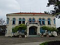 Bến Tre Museum
 -
 Bến Tre Market
 -
 Trúc Giang Lake


References
[edit]- ^ "Completed results of the 2019 Vietnam population and housing census" (PDF). General Statistics Office. Retrieved 7 July 2022.
- ^ Thạch Phương, Tứ Đoàn, Phương Thảo Nguyễn Địa chí Bến Tre 1991 "Only in Bao and Minh islets, there had been 70 schools of Chinese characters in 152 villages until the French occupied Ben Tre (1867). That was a very rare proportion at that time. The list of the Ben Tre successful candidates written in the...."
External links
[edit]- Ben Tre - The third Coconut Festival 2012[permanent dead link]
- Bến Tre Hôm Nay
- Official website of Ben Tre province (English ver.)
- Michael D. Miller. Saving Ben Tre: American veteran's account of Bến Tre during the Tet Offensive
10°14′N 106°23′E / 10.233°N 106.383°E

| International | |
|---|---|
| National | |
| Geographic | |