Crib Point, Victoria
| Crib Point Victoria | |||||||||||||||
|---|---|---|---|---|---|---|---|---|---|---|---|---|---|---|---|
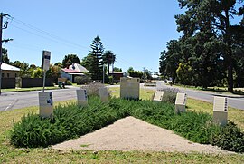
 Entering Crib Point | |||||||||||||||
 | |||||||||||||||
| Coordinates | 38°21′47″S 145°12′07″E / 38.363°S 145.202°E | ||||||||||||||
| Population | 3,343 (2021 census)[1] | ||||||||||||||
| • Density | 531/km2 (1,374/sq mi) | ||||||||||||||
| Postcode(s) | 3919 | ||||||||||||||
| Area | 6.3 km2 (2.4 sq mi) | ||||||||||||||
| Location | |||||||||||||||
| LGA(s) | Shire of Mornington Peninsula | ||||||||||||||
| State electorate(s) | Hastings | ||||||||||||||
| Federal division(s) | Flinders | ||||||||||||||
| |||||||||||||||
Crib Point is a town on the Mornington Peninsula in Melbourne, Victoria, Australia, 64 km (40 mi) south-east of Melbourne's Central Business District, located within the Shire of Mornington Peninsula local government area. Crib Point recorded a population of 3,343 at the 2021 census.[1]
The town is part of an urban enclave on Western Port comprising Bittern, Crib Point, Hastings, Tyabb, and Somerville.
Crib Point is served by three railway stations: Morradoo, Crib Point and Stony Point, the latter of which is the terminus of the greater-metropolitan Stony Point line.
Crib Point Post Office opened on 18 July 1890.[2]
The town has an Australian Rules football team competing in the Mornington Peninsula Nepean Football League.
It is situated near the HMAS Cerberus naval base.
It is opposite a park that has a long stretch of mangroves.
The Victorian Maritime Centre is temporarily located at Crib Point. It has a future permanent site announced at Hastings. The museum houses many artefacts of both the Royal Australian Navy and the Merchant Navy.[3]
Internationally Significant Ramsar Listed Wetland and UNESCO Biosphere Reserve[edit]
Crib Point is one of the coastal villages of the Mornington Peninsula.[4] This coastline is part of the internationally significant Ramsar listed wetland which covers most of Westernport Bay - an area of 59,297ha.[5] It is also a UNESCO Biosphere Reserve - Western Port Biosphere Reserve.[6] Despite these two significant and critical attributes which mean it is fundamental to birdlife, fish breeding and many unique species, there has been unrelenting pressure to exploit this natural asset since the 60s. To this day, there are the remains of industry at Crib Point
The communities of Westernport have successfully fought off attempts to reindustrialise the area.
History:
- 1965 to 1985 – BP Westernport Refinery at Crib Point jetty
- 1987 - Proposed Western Mining ammonia-urea plant (STOPPED)
- 1992 - Proposed Shell-Mobil "super-tanker" project (STOPPED)
- 2007 - Proposed Boral Bitumen plant (STOPPED)
- 2011 - Port of Hastings Container Port strategy (STOPPED)
Climate[edit]
Crib Point has an oceanic climate with relative small thermal differences between seasons, but is still prone to temperature extremes upon northerly winds both in summer and winter.
| Climate data for HMAS Cerberus (1991-2017 normals) | |||||||||||||
|---|---|---|---|---|---|---|---|---|---|---|---|---|---|
| Month | Jan | Feb | Mar | Apr | May | Jun | Jul | Aug | Sep | Oct | Nov | Dec | Year |
| Record high °C (°F) | 44.1 (111.4) |
45.8 (114.4) |
39.7 (103.5) |
34.1 (93.4) |
25.6 (78.1) |
21.7 (71.1) |
21.9 (71.4) |
25.1 (77.2) |
28.9 (84.0) |
34.7 (94.5) |
36.8 (98.2) |
42.4 (108.3) |
45.8 (114.4) |
| Mean daily maximum °C (°F) | 24.5 (76.1) |
25.0 (77.0) |
23.1 (73.6) |
19.8 (67.6) |
16.6 (61.9) |
14.2 (57.6) |
13.6 (56.5) |
14.6 (58.3) |
16.5 (61.7) |
18.6 (65.5) |
20.6 (69.1) |
22.4 (72.3) |
19.1 (66.4) |
| Mean daily minimum °C (°F) | 13.9 (57.0) |
14.3 (57.7) |
12.6 (54.7) |
10.0 (50.0) |
8.4 (47.1) |
6.8 (44.2) |
6.3 (43.3) |
6.6 (43.9) |
7.6 (45.7) |
8.8 (47.8) |
10.7 (51.3) |
11.9 (53.4) |
9.8 (49.7) |
| Record low °C (°F) | 5.2 (41.4) |
5.0 (41.0) |
2.2 (36.0) |
−1.7 (28.9) |
−1.1 (30.0) |
−1.8 (28.8) |
−3.0 (26.6) |
−2.4 (27.7) |
−0.3 (31.5) |
−0.9 (30.4) |
1.6 (34.9) |
3.3 (37.9) |
−3.0 (26.6) |
| Average precipitation mm (inches) | 38.4 (1.51) |
39.4 (1.55) |
45.6 (1.80) |
62.4 (2.46) |
68.7 (2.70) |
72.3 (2.85) |
72.7 (2.86) |
75.2 (2.96) |
67.5 (2.66) |
66.8 (2.63) |
54.0 (2.13) |
53.6 (2.11) |
716.6 (28.22) |
| Source: [7] | |||||||||||||
See also[edit]
- Shire of Hastings – Crib Point was previously within this former local government area.
References[edit]
- ^ a b Australian Bureau of Statistics (28 June 2022). "Crib Point (Suburbs and Localities)". 2021 Census QuickStats. Retrieved 11 July 2022.
- ^ Phoenix Auctions History, Post Office List, retrieved 13 March 2021
- ^ "Victorian Maritime Centre". Victorian Maritime Centre. Retrieved 26 August 2019.
- ^ "Western Port Coastal Villages & Surrounding Settlements Strategy". www.mornpen.vic.gov.au. Retrieved 11 May 2020.
- ^ "Department of Agriculture, Water and the Environment". Department of Agriculture, Water and the Environment. Retrieved 11 May 2020.
- ^ "westernport ramsar listed wetland - Google Search". www.google.com. Retrieved 11 May 2020.
- ^ "CERBERUS station information". Bureau of Meteorology. Retrieved 14 February 2018.


